

- Arunachal Pradesh particularly the north western region was home to the Monpa kingdom of Monyul which flourished between 500 BCE to 600 CE.
- Monpa people were skilled in agriculture and played a major role in trade between Assam and Tibet. They controlled the trade routes and collected taxes from their subjects which was recorded in historical texts.
- One of the notable ruler of Monyul was Gongkar Gyal a descendant of an exiled Tibetan prince Lhase Tsangma. His lineage established local governance and chiefdoms in the area.
- The region known as Lhoyu which corresponds to modern day Arunachal Pradesh was under the control of Tubo Kingdom (or Tibetan Empire) around 7th century CE. During this time the chiefs of Monyul were often subordinate to the rulers of Tawang who recognized the authority of the Tibetan government based in Lhasa.

- Administration in Monyul was under Tibetan influence.
- Tibetan government in Lhasa appointed officials known as Gellongs to oversee local Monpa chiefs.
- The chief responsible for the Duar (trade routes) was called Tsorgon a post established in 16th century.
- Historical records such as Rgyal rigs text written around 1668 or 1728 mention taxes collected from Monpa people. These taxes could be paid in coins, foodstuffs or livestock and was essential for local governance.
- Monpas (known as Menba in Chinese) were part of trade activities in the region especially at Koriapar Dooar in Sonitpur district. In short during ancient times Arunachal Pradesh was a land of Monpa culture, agriculture and trade with Tibet and Assam.
- Administration was under Tibetan governance which resulted in a unique blend of local and external authority that shaped the region’s history.

- In the 17th century, the 5th Dalai Lama, Ngawang Lobsang Gyatso, established Tibetan control over portions of modern-day Arunachal Pradesh. He implemented a tax called Khrey on the Monpa people of that region and ordered the construction of fortresses (Dzong) for administration and the collection of taxes. The collected taxes were sent to the Tawang Monastery
A very important figure in the region's history is the 6th Dalai Lama, Tsangyang Gyatso, born in Tawang. He left a legacy of cultural and architectural contributions to Tibetan Buddhism

- The foothills and plains of Arunachal Pradesh were under the rule of the Chutia kings of Assam. Their influence is evident in archaeological sites such as:
- Bhismaknagar Fort (8th–15th century), showcasing advanced Chutia architecture and administration.
- Malinithan Temple (13th–14th century), a stunning example of temple architecture at the foot of the Siang hills.
- Ita Fort (14th–15th century), in Itanagar, reflecting the Chutia cultural legacy.
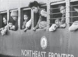
- In 1912–13, the British Indian government established the North-East Frontier Tracts, dividing the region into three sections:
- Ballipara Frontier Tract
- Lakhimpur Frontier Tract
- Sadiya Frontier Tract
- This laid the foundation for Arunachal Pradesh’s modern administrative divisions.

- During the Simla Conference of 1913–14, British administrator Sir Henry McMahon drew the McMahon Line (550 miles or 890 km), defining the border between British India and Tibet.
- This agreement placed Tawang and nearby areas within British India. While Tibetan representatives accepted the accord, Chinese government did not, telling that Tibet region lacked the sovereignty to sign treaties.
- For decades, the McMahon Line faced no serious challenges due to China's limited influence in Tibet.
- In 1938, the British officially published the Simla Accord and a map marking the McMahon Line as the border.

Kangto Peak
- Highest peak in Arunachal Pradesh
- Elevation:7,089 meters
- Located in the Eastern Himalayas
Nyegyi Kangtsang
- Elevation of 7,047 m
- The Peak is also known as Katoie Gyang
- Located in the Eastern Himalayas
Gori Chen
- Elevation of 6,488 m
- Located in the Eastern Himalayas
Dapha Bum
- Elevation of 6,488 m
- Located in the Mishmi Hills and Patkai Range
- The Namdapha River originates from the Dapha Bum glaciers
Miao Bum
- Elevation of 6,488 m
- Located in mountain range is called Patkai Bum
- The Namdapha tiger project is here
Bum La
- It connects India - Tibet
- It was also closed after the Chinese aggression on India in 1962 and was reopened in 2006.
- Border Personnel Meeting point
Diphu Pass
- It is near the trijunction of India, China, and Myanmar.
- It lies on the McMohan Line, which demarcates India and China
Bomdila Pass
- It is located in West Kameng district
Sela Pass
- It lies along the National Highway 13 (NH 13)
- Sela Lake, a sacred lake in Tibetan Buddhism, lies near the summit of this pass.
Yonggyap pass
- It lies on the Indo-China border
Dihang Pass
- its is also known as the Siang Pass
- it connects India - Myanmar
Pangsau Pass
- It connects India - Myanmar
- During World War II this pass became famous because of the Stilwell Road (Ledo Road) connecting British India to China.

Mouling NP
- It is located in the right bank of river Siang
- Many endangered species like takins, snowclouded leopard, golden languor, hornbill, monal scalater, serrow are spotted here.
Namdapha National Park
- Evergreen Rainforest
- In 2024, it was declared as a Eco-Sensitive Zone.
- It is a Tiger Reserve also
- Rafflesia flora recorded here
- Namdapha flying squirrelare found here. It is a critically endangered species.
Dibang Wildlife Sanctuary
Pakhui Wildlife Sanctuary
- It is also a Tiger Reserve cakked as Pakke Tiger Reserve
- It is bounded by Bhareli or Kameng River in the west and north, and by Pakke River in the east.
- It has won India Biodiversity Award 2016 in the category of 'Conservation of threatened species' for its Hornbill Nest Adoption Programme.
D'Ering Memorial Wildlife Sanctuary
- Most of this sanctuary, about 80% is covered with grass
Mehao Wildlife Sanctuary
- It tries to conserve the biodiversity around the Mehao Lake
Kamlang Wildlife Sanctuary
- It was the 50th Tiger reserve in India.
- In 2024, it was declared as a eco-sensitive zone.
- The sanctuary is the habitat of the four big cat species of India: tiger, leopard, clouded leopard and snow leopard.
- Mishmi, Digaro Mishmi, and Miju Mishmi tribal people reside here.
Talle Valley Wildlife Sanctuary
Eagle's Nest Wildlife Sanctuary
Itanagar Wildlife Sanctuary
Kamala Wildlife Sanctuary
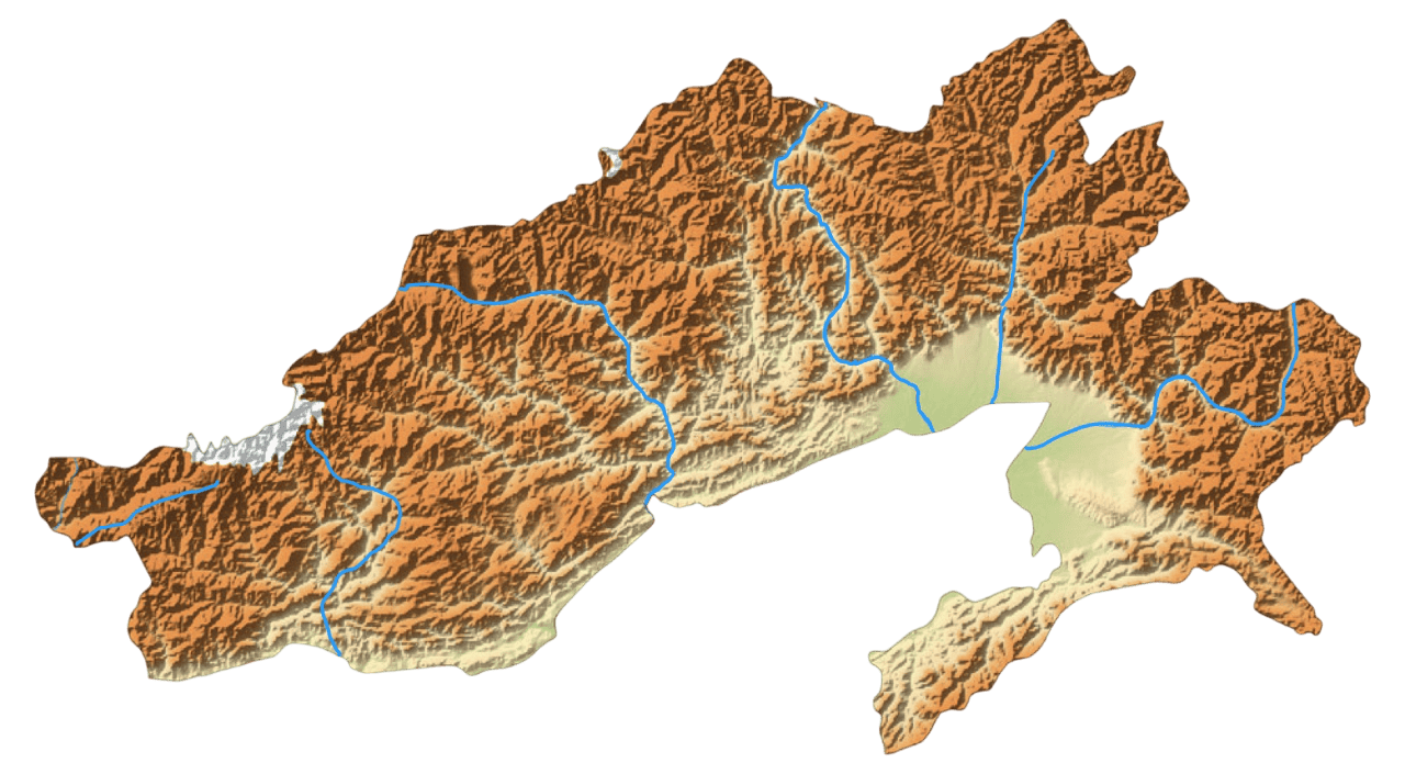
Lohit River
- Originates in eastern Tibet where it is known as the Zayu River
- Two main tributaries merge to form the Lohit – the Kangri Karpo Chu and the Zayul Chu.
- Flows through Mishmi Hills
- At the end of its course through Arunachal Pradesh, the Lohit meets the Siang River. After this joins Bhramaputra river.
Dibang River
- Known as Sikang and Talo
- Originating near Keya Pass on the Indo-Chinese border.
- Flows through Mishmi Hills.
Brahmaputra River System
- The river originates from the Kailash ranges of Himalayas, Chemayungdung glacier, Manasarovar
- Arunachal Pradesh has the highest drainage basin and after that Assam
- In Tibet where it is known as the Yarlung Tsangpo River
- Right Bank Tributaries: Kamek River, Manas River, Torsa River, Raidak River, Jaldhaka River, Sankosh River, Gadadhar River
- Left Bank Tributaries: Lohit River, Dibang River, Subansiri River, Dhansiri River, Kopili River, Teesta River
Subansiri River
- Largest tributary of Brahmaputra
- Subansiri Lower Hydroelectric Project
Kameng River
- Source : confluence of rivers from the Goshu Lake and the Gori Chen mountain glacier
- Major Tributaries : Bichom River, Tenga River, Dirang Chu River, Tippi River.
- Home to Monpa, Sherdukpen, Aka Tribes
Tawang River
- Source : Originates from Gori Chen mountain
- Tributaries : Nyamjang Chu (main tributary)
- Major Waterfalls : Nuranang Falls ( Bong Bong Falls )
Sally Lake
Mehao Lake
Geker Sinying Lake ( Ganga lake )
Panga Teng Tso Lake
Madhuri Lake
Sela Lake