
Ancient History
500 BCE - 600 CE
Rise of Monpa Kingdom

- Arunachal Pradesh particularly the north western region was home to the Monpa kingdom of Monyul which flourished between 500 BCE to 600 CE.
- Monpa people were skilled in agriculture and played a major role in trade between Assam and Tibet. They controlled the trade routes and collected taxes from their subjects which was recorded in historical texts.
- One of the notable ruler of Monyul was Gongkar Gyal a descendant of an exiled Tibetan prince Lhase Tsangma. His lineage established local governance and chiefdoms in the area.
- The region known as Lhoyu which corresponds to modern day Arunachal Pradesh was under the control of Tubo Kingdom (or Tibetan Empire) around 7th century CE. During this time the chiefs of Monyul were often subordinate to the rulers of Tawang who recognized the authority of the Tibetan government based in Lhasa.
Ancient History
Administration
Administration of the the Monyul

- Administration in Monyul was under Tibetan influence.
- Tibetan government in Lhasa appointed officials known as Gellongs to oversee local Monpa chiefs.
- The chief responsible for the Duar (trade routes) was called Tsorgon a post established in 16th century.
- Historical records such as Rgyal rigs text written around 1668 or 1728 mention taxes collected from Monpa people. These taxes could be paid in coins, foodstuffs or livestock and was essential for local governance.
- Monpas (known as Menba in Chinese) were part of trade activities in the region especially at Koriapar Dooar in Sonitpur district. In short during ancient times Arunachal Pradesh was a land of Monpa culture, agriculture and trade with Tibet and Assam.
- Administration was under Tibetan governance which resulted in a unique blend of local and external authority that shaped the region’s history.
Medieval history
Tibetan Influence and Administration
5th Dalai Lama

- In the 17th century, the 5th Dalai Lama, Ngawang Lobsang Gyatso, established Tibetan control over portions of modern-day Arunachal Pradesh. He implemented a tax called Khrey on the Monpa people of that region and ordered the construction of fortresses (Dzong) for administration and the collection of taxes. The collected taxes were sent to the Tawang Monastery
A very important figure in the region's history is the 6th Dalai Lama, Tsangyang Gyatso, born in Tawang. He left a legacy of cultural and architectural contributions to Tibetan Buddhism
Medieval history
Arunachal and Chutia Kings
Role of Chutia Kings

- The foothills and plains of Arunachal Pradesh were under the rule of the Chutia kings of Assam. Their influence is evident in archaeological sites such as:
- Bhismaknagar Fort (8th–15th century), showcasing advanced Chutia architecture and administration.
- Malinithan Temple (13th–14th century), a stunning example of temple architecture at the foot of the Siang hills.
- Ita Fort (14th–15th century), in Itanagar, reflecting the Chutia cultural legacy.
Modern history
British Era
Formation of the North-East Frontier Tracts
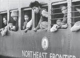
- In 1912–13, the British Indian government established the North-East Frontier Tracts, dividing the region into three sections:
- Ballipara Frontier Tract
- Lakhimpur Frontier Tract
- Sadiya Frontier Tract
- This laid the foundation for Arunachal Pradesh’s modern administrative divisions.
Modern history
British Era
The McMahon Line and the Simla Accord

- During the Simla Conference of 1913–14, British administrator Sir Henry McMahon drew the McMahon Line (550 miles or 890 km), defining the border between British India and Tibet.
- This agreement placed Tawang and nearby areas within British India. While Tibetan representatives accepted the accord, Chinese government did not, telling that Tibet region lacked the sovereignty to sign treaties.
- For decades, the McMahon Line faced no serious challenges due to China's limited influence in Tibet.
- In 1938, the British officially published the Simla Accord and a map marking the McMahon Line as the border.

Phawngpui Tlang Peak
- It is the highest mountain peak in the Mizo Hills (Lushai Hills)
- Elevation: 2157 meters
- Also known as Blue Mountain.
- Mountain goats live in this hill.
Lengteng
- Elevation of 2,141 m
- It is an alpine forest and contains the second highest peak in Mizoram
- An IUCN-classified vulnerable species of primate, northern pig-tailed macaque is reported here.
Surtlang
- Elevation of 1967 m
- It is the third highest mountain in the state.
Lurh Tlang
- Elevation of 1935 m
- The 4th highest mountain in Mizoram.
Tan Tlang
- Elevation of 1837 m.

Murlen NP
- Situated close to the Indo - Myanmar border of Champhai District.
- This NP is well known for being one of the few remaining refuges of Mizoram state bird, Vavu (Mrs Hume's Pheasant).
- Important Birds- Mrs. Hume’s pheasant (Vavu), Kaleej pheasant (Vahrit), Bhutan peacock pheasant (Varihaw), Red jungle fowl (Ramar), Pied hornbill (Vahai), Imperial pegion (Bullut), Creted serpent eagle (Muvanlai), Brown wood owl (Chingpirinu), Hoopoe (Chhuangtuar) etc
- Important Wild Animals- Tiger (Sakei), Leopard (Keite), Goral (Sathar), Serow (Saza), Sambar (Sazuk), Barking deer (Sakhi), Wild boar (Sanghal), Rhesus macaque (Zawng).
Phawngpui National Park
- It is located in the Phawngpui Hills, also known as the Blue Mountain Hills
- Home to rare avian species like Blyth's tragopan, Mrs. Hume's pheasant, dark-rumped swift.
- Mammals like Asiatic black bear, slow loris, stump-tailed macaque ,capped langur, goral , tiger , and leopard.
- The steep slopes are covered by orchids and rhododendrons to make enchanting sight .
Dampa Tiger Reserve & Sanctuary
- It was designated as a tiger reserve in 1994.
- Primarily to safeguard the endangered Bengal tigers.
Ngengpui Wildlife Sanctuary
- Named after the Ngengpui River.
- The sanctuary features tropical wet evergreen forests, montane subtropical forests, and jhum forests.
- The climate is characterized by high rainfall and humidity throughout the year.
Khawnglung Wildlife Sanctuary
- It is located in the Lunglei District of Mizoram.
- Subtropical semi-evergreen forests, with bamboo being the most common species of flora in the region.
Lengteng Wildlife Sanctuary
- It is an alpine forest and contains the second highest peak in Mizoram.
- Vulnerable - Northern pig-tailed macaque is reported here.
Tawi Wildlife Sanctuary
- It is one of the first sanctuaries of Mizoram notified in 1978 with tropical Evergreen and Semi Evergreen.
Thorangtlang Wildlife Sanctuary
- It has unique natural feature of Evergreen & Semi-Evergreen forests
Pualreng Wildlife Sanctuary
Tokalo Wildlife Sanctuary
- It is home to the largest lake in Mizoram, known as Palak Lake.

Tlawng River
- It is one of the longest rivers in Mizoram. Length 185.15km.
- Main tributaries Tut, Teirei and the Ngashih
- The city Aizawl is situated on the east bank of the river.
Tiau River
- It rises near Khuangphah village of Champhai district.
- It ultimately merges with the Kaladan River.
- This river flows through the international border between Mizoram state in India and Chin state in Myanmar .
Teirei System
- It is the tributary of Tlawng river.
Tuichawng River
- Tributary of Karnaphuli river
Tuivawl River
Tuivai River
- Source : originates in Chin Hills in Myanmar ,flows through the states of Manipur, Mizoram and Assam in India
- Longest tributary of the Barak River
- Major Waterfalls : Nuranang Falls ( Bong Bong Falls )
Tuipui River
Tuichang River
Koladyne or Tuipui River
- It is called the Chhimtuipui River in India.
- It forms the international border between India and Burma.
Palak Dil Lake
- It is the largest and biggest lake.
- It has been designated as a protected Ramsar site since 2021.

Add Your Tooltip Text Here